
In our three-part examination of the missing scientists, we made a claim about Monica Reza that carried a lot of weight: she vanished thirty feet behind a companion, in minutes, on a trail she hiked every week, and a week-long multi-agency search recovered only a beanie and some lip balm. We called that profile anomalous. We meant it as an evidentiary judgment, not a rhetorical one.
Since then we obtained the georeferenced search data — the volunteer CalTopo map that aggregates GPS tracks from the search parties, along with the plotted locations of where the two items were recovered. That data lets us do something the coverage so far has not: stop describing the disappearance in words and start measuring it. This piece is only about that. Not the Mondaloy connection, not McCasland, not the timing bracket. Just the trail, the two items, and what the geometry does and does not permit.
Here is the short version. We tested the most boring possible explanation — she wandered off-trail and the terrain redistributed her belongings downhill — against the actual elevation and bearing data. It fails. Not “strains.” Fails. And the way it fails is specific enough to be worth walking through carefully, because the whole point of holding a standard is showing your work when the test could have gone against you.
The five points
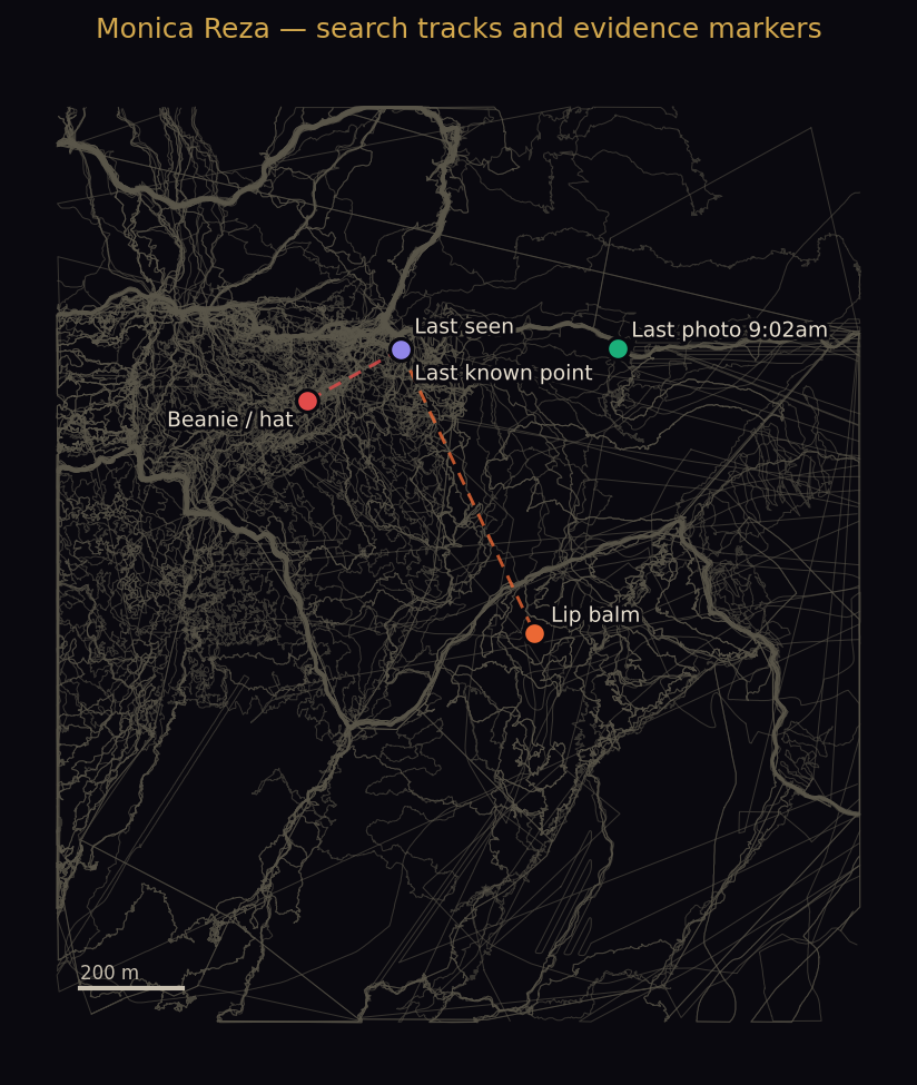
The record gives us five georeferenced points. The last three are the trail sequence: her last photo at 9:02 a.m., her last known point, and the last-seen position. The two that matter for the physical record are the recovered items. Here is the full set, with elevations interpolated from search-party GPS tracks that passed directly over each point.
| Point | Elevation | Distance from LKP | Bearing |
|---|---|---|---|
| Last photo (9:02 a.m.) | 2,310 m | 421 m | 090° E |
| Last known point | 2,290 m | — | — |
| Last seen | 2,290 m | ~0 m | — |
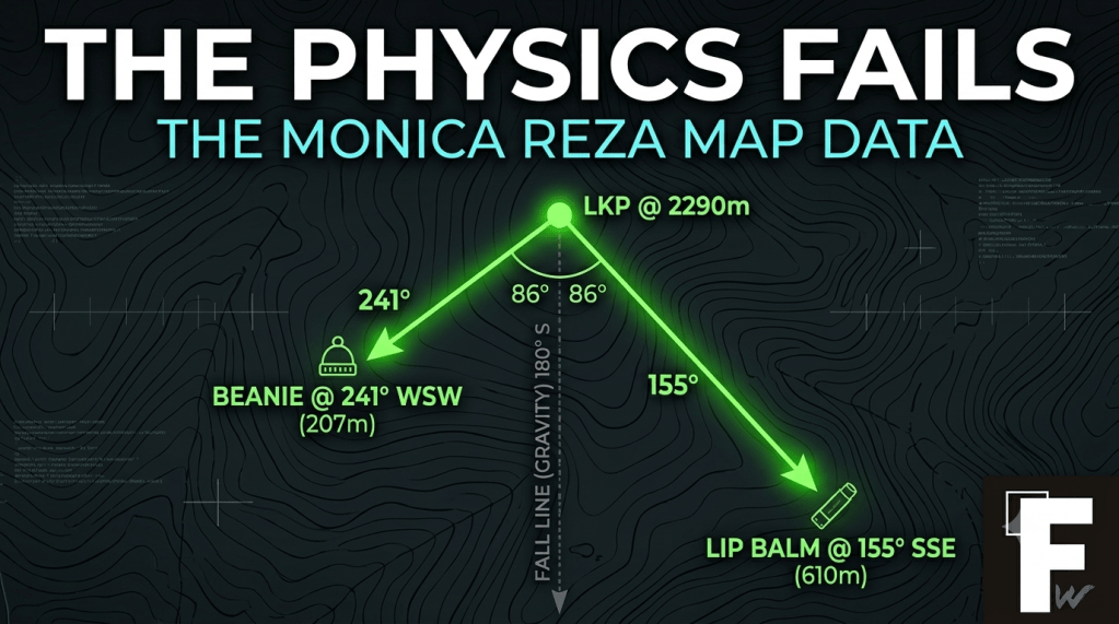
| Beanie / hat | 2,157 m (−133 m) | 207 m | 241° WSW |
| Lip balm | 2,123 m (−167 m) | 610 m | 155° SSE |
LKP = last known point. Bearings and distances are measured from the last known point. Elevations are interpolated from GPS search tracks passing within 0.3–1.6 m of four markers, and ~26 m of the lip balm point.
First problem: the items are far out
The two recovered items are not at the spot she was last seen. The beanie is 207 meters out. The lip balm is 610 meters out. That already breaks the intuitive picture of “she stepped off the trail edge and dropped them.” Those are real distances across steep terrain. Getting belongings that far from the last-seen point requires substantial movement — hers, or someone’s, or the terrain’s.
That is the fork. Either she moved out there under her own power, or something/someone moved the items. Both branches have to survive the same two facts, and this is where it gets hard for every ordinary explanation.
Second problem: no scent trail
Search canines reached the ravine below the trail and lost the track. This is the single most underweighted fact in the case. A dog works a scent corridor, and a person self-propelling 200-plus meters downslope lays one down. The dogs didn’t hold it. That is direct evidence against self-propelled movement to the recovery points — which is exactly the movement the item distances would otherwise require. The “she wandered” reading needs her to have traveled; the scent record says she didn’t travel in the way a traveler travels.
Third problem: the search was saturating and the box is small
All of this sits inside a box only a few hundred meters across. That box got helicopters, FLIR, drones, multiple canine deployments, and multi-agency ground teams for over a week. That is one of the more thorough searches run in that region in years, over a small, defined area. It produced two small objects and nothing else. No body. No drag sign. No blood, no disturbance on the trail surface, no further trace in any direction. A saturation search of a small box that yields two items and no person is not the signature of a body that is simply hard to find. It is the signature of a body that, by the physical record, is not in the box.
The test that could have ended this: the fall line
Here is the honest part. There was one mundane explanation still standing after all of the above, and it applies specifically to the beanie. Maybe she dropped it near the trail and it rolled — a light object on a steep slope can travel a long way downhill on its own. If that were true, the beanie’s position wouldn’t tell us anything anomalous. It would just be gravity.
That is a testable claim. A passively rolling or sliding object goes down the fall line — the direction of steepest descent. So we measured two things: how far the beanie actually dropped, and whether the direction it ended up in matches the direction gravity would have carried it.
The drop is real. The beanie sits 133 meters below the last known point — a 64% average grade. Steep enough that “it rolled” is a serious hypothesis, not a strawman. So far the rescue survives.
Then you check the direction, and it dies.
The trail runs along a ridge crest — we know this because her 9:02 photo point is 20 meters higher and directly east, which means the ridge line runs east–west. Off an east–west ridge, the fall line — straight downhill — points due south, 180 degrees.
The beanie’s bearing from the last known point is 241 degrees. That is 61 degrees off the fall line. A dropped object does not roll 61 degrees across the slope and stop there. Gravity doesn’t work sideways.
And the lip balm makes it worse, not better. Its bearing is 155 degrees — 25 degrees off the fall line, on the other side of it. So the two items didn’t even diverge the same way. Passive terrain redistribution can, in principle, roll one object downhill. It cannot roll two objects onto two different cross-slope bearings, 86 degrees apart from each other, neither of them aligned with the direction the slope actually falls.
We went looking for the explanation that would let us take the anomaly flag down. We found the measurement that removes it instead.
What survives
Sort it the way we sort everything. One explanation is eliminated by the physical record. What remains is a short list, and we are not going to pretend the data picks a winner it doesn’t pick.
So the terminal claim is this, stated as precisely as we can state it: the physical record excludes the wandered-off-trail explanation and excludes passive terrain redistribution of the items. What remains as most likely is foul play or a pattern matching no known profile. The physical signature is well-accounted-for by neither, and the current evidence does not distinguish between them.
We are not naming a cause. We looked at the two survivors and noticed that both of them fail to match a known profile — which is the finding. It is not that “normal foul play” is competing with “something anomalous.” It is that the physical signature is unaccounted-for on every branch that survives elimination. That is a narrower and more defensible statement than picking one, and it is the honest read of the numbers.
The flag is provisional
One thing we want to be explicit about, because it is what separates this from the noise. The anomalous flag on this case is contingent on the evidence structure, and it comes down the moment new evidence changes that structure. If a body is recovered, if a scent result is revised, if the item locations turn out to be mis-plotted, if a mechanism surfaces that accounts for the dispersal — the flag retracts. We are not committed to the conclusion. We are committed to the standard. Right now the standard says: this doesn’t fit.
Sourcing and limits
The marker coordinates and item locations come from the volunteer CalTopo map maintained by the search community, not from an official LA County Sheriff’s Department survey release. We rate them high-confidence-unofficial: precise as plotted, but community-sourced. The elevations are interpolated from GPS tracks that passed directly over the points — consumer-GPS elevation carries a few meters of error, which is irrelevant against a 133-meter drop but worth stating. The fall-line direction follows the local ridge geometry the track data shows. A micro-terrain chute could bend a short path, but it cannot hold a passively moving object 61 degrees off gravity for 207 meters. If the Sheriff’s Homicide Bureau, which holds the open case, releases surveyed coordinates that differ from these, that supersedes our numbers, and we will say so.
This is a companion note to the Mondaloy chain series, and it stays in its lane. It does not touch the programmatic chain, the institutional-silence pattern, or the timing bracket — those arguments stand on their own record. What it does is sharpen the anchor node. Reza was the case that met our standard on the strength of what happened on that trail. The map data doesn’t soften that. It raises the evidentiary bar: the mundane explanations that would have let the case go quiet don’t survive contact with the elevation and the bearings.
As always: confirmed fact, direct measurement, and open question are different things, and we have tried to label them throughout. The case remains open with the LA County Sheriff’s Homicide Bureau. If you have standing to investigate, the numbers above are where the trail work starts.

